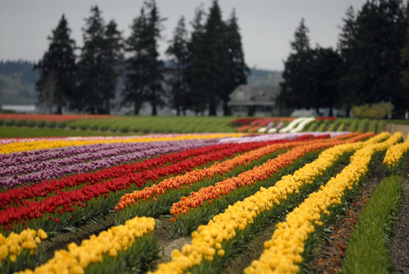
The Loretto Chapel of Sante Fe

loretto-chapel-2


The Loretto Chapel in old Sante Fe, New Mexico is as mysterious as it is beautiful. While attending the Women Writing the West writers’ conference, I joined our group on a walking tour of the old Sante Fe’s historic district. The highlight of that tour was the Loretto Chapel.

Loretto Chapel was almost completed in 1878 when the builders realized the chapel had a major flaw: there was no access to the choir loft twenty-two feet above. Carpenters were called in to address the problem, but they all concluded that building a staircase would take too much space from the limited seating of the small chapel, and that the only access would be a ladder.

The Sisters of the Chapel made a novena to St. Joseph, the patron saint of carpenters. On the ninth and final day of prayer, a man appeared with a donkey and toolbox looking for work. He had two requirements: that he work completely alone and that the nuns furnish vats of hot water several times a day. They honored his request.

Months later, on the appointed day, the nuns entered the chapel to find an elegant circular staircase with two 360-degree turns and no visible means of support. The staircase was built without nails, only wooden pegs. Mysteriously, the carpenter disappeared without pay or thanks.

The staircase was said to sway slightly and ten years later bannisters were installed for safety in climbing to the loft.

Today the chapel is a private museum and maintained for the preservation of the Miraculous Staircase and the Chapel itself. Besides museum visitors, the Chapel is a popular site for weddings.

If you’re in Sante Fe, be sure to visit this lovely chapel. It’s an amazing experience.

Mitchell Monument: A Remembrance of World War II

Photo credit: Michael McCullough (CC BY 2.0)

Photo credit: Michael McCullough (CC BY 2.0)


While driving along Oregon Route 140 in southern Oregon, we discovered a poignant and sobering memorial. The small picnic site is managed by the Fremont-Winema National Forest in the Bly Ranger District.

A monument made of native stone and displaying a bronze plaque is the pivotal attraction of the recreational area. The Mitchell Monument is dedicated to six picnickers, the only World War II casualties to occur on continental U.S. soil as the result of enemy action.

On May 5, 1945, Reverend Archie Mitchell, his pregnant wife Elsie, and five of his Sunday school students planned a picnic about five miles northeast of Bly, Oregon. They stopped at Leonard Creek on Gearhart Mountain. Archie let Elsie and the children out to explore while he parked the car.

Before he’d even left the car or turned off the engine, he heard his wife call to him to look at what they had found. He observed the group huddled around a foreign-looking object and saw one of the children reach for it. Before he could step out of the car, an explosion shattered the area, killing his wife and the five children. Archie was the only survivor.

The object they’d found was a Japanese fugo, a simply-designed wind-driven bombing balloon. The fugo balloons, developed in the final months of World War II, were hoped to create psychological terror, death and destruction in the continental United States. The balloons were launched in Japan and carried by the jet stream, an easterly blowing wind current. About 300 of the 9,000 balloon-bombs launched were found in several states—Alaska, Washington, Oregon, California, Arizona, Idaho, Montana, Utah, Wyoming, Colorado, Texas, Kansas, Nebraska, South Dakota, North Dakota, Michigan and Iowa, as well as Mexico and Canada.

The United States government knew the country was under attack but ordered the media not to disclose information, hoping to minimize public awareness and also to prevent the Japanese from discovering their mission’s success. The silence proved valuable. Americans were not alarmed and Japan believed their mission had failed.

In 1945, after the Mitchell party tripped a balloon bomb, the government finally alerted the public to the danger. By then, the Japanese were no longer sending fugos.

In August, 1950, the Weyerhaeuser Timber Company, which owned the bomb site, dedicated a memorial to the six who perished

In later years, on a trip to Japan, Yuzuru John Takeshita, a former internment camp prisoner, was told how a friend and her classmates were taken out of school to work in a factory to make paper balloon bombs. When told of the tragedy, the former students, moved by regret and compassion, asked Takeshita to deliver 1,000 paper cranes to the families of the victims. Paper cranes, the Japanese symbol of healing and peace, were sent as good-will gifts. In addition, six cherry trees were also delivered to Bly with the former Japanese students’ condolences. The trees were planted at a re-dedication ceremony in 1995.

The Memorial plaque lists the victims of the fugo bomb:
Mrs. Elsie Mitchell, age 26
Jay Gifford, age 13
Edward Engen, age 13
Dick Patzke, age 14
Joan Patzke, age 13
Sherman Shoemaker, age 11

Idaho’s Bruneau Dunes State Park

Bruneau Obs Dune

On a typical two-week vacation, we stay at a difference place practically every night. Traveling with a truck and camper, this is how we like to spend our vacations. The exception is the weekend between the two weeks. Then we usually try to spend Friday and Saturday nights in the same place, since a campsite can be harder to find on a weekend.

This year, it was our good fortune that we stopped at Bruneau Dunes State Park in southwest Idaho’s high desert. With so much to do and see, it was a perfect place to spend two nights. The 4,800-acre park is the site of North America’s highest single-structured sand dune, which is approximately 470 feet high. (North America’s highest multi-structured dune is at Great Sand Dune National Park in Colorado and is approximately 660 feet higher than its immediate base.)

The dunes at Bruneau are unique in North America. While other dunes in the Americas form at the edge of a natural basin, the Bruneau Dunes form near its center. The dunes are ancient, probably forming with sands from the Bonneville Flood about 15,000 years ago. These dunes are fairly stable with winds blowing from the southeast and from the northwest. Unlike most dunes, these do not drift far.

No vehicles are allowed on the dunes, but visitors may climb and even zoom down on sand boards, similar to snow boards. Seven- and nine-mile horseback riding trails wind around the dunes. An equestrian overnight facility, with corrals, is also available.

We found the campsites spacious with grassy lawns and shade from willow and cottonwood trees. Eighty-two sites have water and electricity, plus there are 31 standard campsites. Two cabins are available for rent.

The park contains several habitats: desert, dunes, prairie, lake and marsh. Wild predators, which are protected within park boundaries, maintain a natural balance of animal population. Fishing for bass and bluegil is popular. It’s a peaceful lake with only non-motorized boats, canoes, rafts and float tubes allowed.

A big attraction at this park is the Steele-Reese Education Center, which includes an observatory. At dusk each Friday and Saturday from April through mid-October local astronomers present a multimedia introduction to the night sky in the comfort of an indoor auditorium. Once the stars begin to twinkle, visitors can observe through the rotating observatory planets, galaxies and nebulae, which I learned is a cloud of gas and dust in outer space. Visitors can observe the night sky through a collection of other equipment, including refractor and catadioptric telescopes.

Bruneau Dunes State Park is just south of Mountain Home, the county seat of Elmore County, and the home to Mountain Home Air Force Base. Mountain Home is a good place to provision and it also has one of the largest laundry facilities I’ve ever seen.

If you’re in southwest Idaho, plan to stop by Bruneau Dunes State Park. It’s a special place.

A Welcomed Oasis: Bates State Park

Bates State Park OPRD VisitorsAlthough it was only mid-June, eastern Oregon was hot. We happened upon Bates State Park, near the headwaters of the Middle Fork of the John Day River, and discovered a lovely oasis with shade trees and green grass. At 4,000-feet elevation, the park offered cool relief at night.

Bates State Park is the site of a former thriving lumber mill that operated for nearly 60 years. The 131-acre park is adjacent to the former Bates company town, home to about 400 families at its peak. In 1975, when a new mill was built in nearby John Day, the Bates mill was shut down and the town gradually disappeared. After the mill and many of the homes were dismantled, the land sat empty for more than 35 years.

A non-profit group, later named Friends of Bates State Park, worked tirelessly for many years advocating for the property’s preservation as a state park. Oregon Parks & Recreation Department purchased the land, and the park officially opened in 2011.

One of the central features of the park is the mill’s log pond. In its hey-day, local mill workers and ranch hands used to water ski in the pond, towed by a pick-up driving the bouncy road at the edge of the pond.

The park offers more than three miles of well-maintained hiking trails along the Middle Fork John Day River, Bridge Creek and Clear Creek. Interpretive panels throughout the park describe Bates life in the early to mid-20th Century and the steps taking place now to restore the land and waterways.

Although the park’s 28 sites do not offer hookups, there’s plenty of space to park rigs or to set up tents.

The area is a rich fish habitat. The Middle Fork of the John Day River and its tributaries are home to Chinook salmon, steelhead, trout and other native fish. Oregon Parks & Recreation are currently in the early stages of a restoration project, including a fish ladder, that would improve access to 14 miles of ideal fish habitat.

We found that Bates State Park makes a great home base when touring the area. The campground is situated between three nearby Wilderness Areas: Strawberry Mountain and Monument Rock to the south and North Fork John Day to the north. Hikers can climb to spectacular views atop Indian Rock and Vinegar Hill, which together make up the summit of the Greenhorn Range of the Blue Mountains.

Bates is convenient to the Old West Scenic Bikeway, a 174-mile loop that passes through landmarks such as John Day Fossil Beds National Monument. The park is also on route for cross-country cyclists touring the TransAmerica Trail, which runs along nearby Oregon Highway 7.

On U.S. Highway 26, nine miles from Bates State Park, we found a nice little hike at the old Sumpter Valley Interpretive Trail that overlooks the historic Dixie Switchbacks. The tracks were used by the Sumpter Valley Railway that connected Prairie City, Oregon to Baker City, Oregon.

Bates State Park was a great find–just our kind of place.

The Blooming Fields of Skagit Valley

Tulips


It’s like viewing the perfect mural—row upon row of dazzling color—brilliant red, sparkling yellow, vivid pink, rakish purple. Though picture-perfect, they’re real, these delightful tulip fields of the Skagit Valley. Not only tulips, but daffodils and iris grace these lovely fields. Although Mother Nature dictates the bloom dates, daffodils bloom first, followed by tulips and finally, iris.

Now extended to cover the entire month of April, this year’s 33rd annual Skagit ValleyTulip Festival also features, in addition to viewing the blooming fields, a packed schedule of events including art shows, wood crafting events, barbecues, quilt walks, and walking tours.

Since the mid-1930s, spring-time visitors to the Skagit Valley have marveled at the striking beauty of tulip, daffodil and iris fields. Northwest Washington, particularly in the Skagit Valley, has become world- famous for its seasonal showcase and for its commercial bulb production. Washington Bulb Company, the nation’s largest tulip, daffodil and iris producer, makes its headquarters in Skagit Valley.

As it happens, the Northwest has perfect bulb-growing climate with cool moist winters, which encourages root growth. Also, relatively cool spring and summer weather helps control diseases common in hotter places. Another factor is well-balanced, level and well-drained soil.

A favorite local story tells about the local gardener who thought he would buy his bulbs that year from the source, Holland. You guessed it. When he received his bulbs from Holland, the package label said the bulbs were grown in the Skagit Valley!

Those who are returning to enjoy the springtime hues will notice that those fields seen last year frequently will not have the same crop this year. That is because flower bulbs, like many other crops, must be rotated to preserve the soil and reduce pest contamination. The flowers rotate to their original field about every five years.

Tulip Festival maps are available at many Skagit Valley stores, but it isn’t necessary to have a map to enjoy the blossoms. Signs indicate the “Tulip Route,” or you may simply drive along until you see a field. If there is a pull-off, park and enjoy the view, or even walk along designated paths. Remember, for some traffic on the road, it’s business as usual and drivers aren’t expecting sudden stops. Also, this is a busy time of year for farmers and heavy equipment will be moving about, so please be patient.

The Skagit Valley growers ask for your cooperation in touring the fields. Be aware that only certain fields are open to visitors. Always observe private property; please don’t trespass to get a picture. Enter only those fields with signs posted that visitors are welcome. NEVER pick a flower—cut flowers are available for sale at various stands.
Two local growers encourage visitors to stop: Roozengaarde and Tulip Town.

Roozengaarde has a three acre display garden with an authentic Dutch windmill. Bulbs and cut flowers are available for purchase—stroll the gardens to find your favorites. At Tulip Town, in addition to the tulips fields and purchasing opportunities, visitors will enjoy more than 100 exquisite tulip arrangements, live music, food, and horse-drawn wagon rides through the tulip fields

Splendid opportunities await eager photographers. Early morning or late afternoon give the best light for picture taking. For really spectacular pictures, include landscape attractions, such as barns or snow-capped Mt. Baker. Tulip fields provide a colorful carpet against the backdrop of the majestic Cascade Mountains.

To get there: The blooming fields are 60 miles north of Seattle, directly off I-5 using exists 221 through 236. All of these exits have tulip brochures at the nearest businesses. The fields are spread out over a 15-mile radius and events are scattered around the entire county. Festival site guide maps are available.

For more information, visit tulipfestival.org or call (360) 428-5959.

Boat Trouble in Mexico

Ancient Marquesas Tikis

Ancient Marquesas Tikis

Excerpt from Sailing with Impunity: Adventure in the South Pacific

While in The Marquesas in French Polynesia, we had dinner with a couple one evening who told us a hair-raising incident that happened to them in Mexico.
.
They had spent an evening visiting on a neighboring sailboat. Just going from their boat to the other boat in their dinghy, they hadn’t taken their shoes, purse or his wallet since they wouldn’t need those items unless they went ashore. They’d had a nice evening playing cards and then, much later, they climbed into their dinghy to return to their own boat. It was dark, but they soon realized their sailboat was gone!

Panicked, they went back to their friend’s boat and spent the rest of the night there. First thing in the morning, they went ashore and reported the missing boat. They didn’t know if it had been stolen, became untied, or dragged anchor, so it was unknown if a crime had been committed.

With no money, no identification, not even shoes, they were in a terrible situation. To their surprise and relief, an American, a man they didn’t know, gave them $500 so they could buy shoes and stay in a hotel until they could receive money from home. No strings attached, he simply wanted to help stranded strangers. (They got his name and address and were able to pay him back.)

Mexican officials put out notices and the couple talked to fishermen and anyone going to sea. Finally, about two weeks after it “went missing” the boat was spotted. The fishermen who saw it said it was merely bobbing along, laundry still hanging in the transom, anchor hanging on its chain in the deep water. It didn’t appear to be damaged.

After observing the boat for some time, the fishermen motored over to it and one climbed aboard, started the engine, weighed anchor, and brought it back to port. Everything was intact, even her purse and their wallets were still there.

The couple continued their journey in their sailboat to The Marquesas, so thankful for the kindness of others.

Where Eagles Soar

Photo by Dana Moos

Photo by Dana Moos

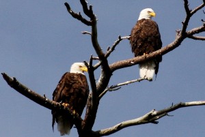
One of Washington’s most spectacular attractions is the wintering population of bald eagles along the Skagit River. Bald eagles, migrating from British Columbia, Alaska and the interior Northwest, come to the Skagit to feed on spawned chum salmon. Their haunting, creaking cackle splits the air as they go about the business of hunting for their food of prey.

The Skagit Eagle Festival is a month-long celebration during eagle-watching season in eastern Skagit County. Activities take place in Concrete, Rockport and Marblemount every full weekend in January. The Festival is devoted to public education on the bald eagle, as well as environmental and wildlife conservation.

The festival features a variety of free tours, walks, and educational programs where visitors will learn not only about these majestic birds, but also about a variety of wildlife and the beautiful areas along the Skagit River where eagles live or return each year. Festival attendees may also enjoy arts & crafts, wine tasting, river rafting, music and dance, plus additional indoor and outdoor activities.

Opportunities abound to view or photograph our majestic national symbol as they congregate along the banks of the Skagit River, typically between December through February. Eastern Skagit County offers one of the largest wintering Bald Eagle populations in the lower 48 states. Peak counts have been estimated at more than 500 birds.

For viewing by land, the Bald Eagle Festival committee recommends parking in the pullouts on Highway 20 at Mileposts 99 and 100. (Avoid parking on narrow highway shoulders which could obstruct highway traffic.) Howard Miller Steelhead Park in Rockport also offers good eagle viewing.

If you would prefer viewing the eagles from the river, private raft companies with certified guides offer float trips on the Skagit and other rivers.

The North American colonists originally gave the bald eagle its name when “bald” or “balled” meant white. Bald eagles feed mostly on fish or seabirds, though they may scavenge larger animals such as deer and even whale carrion.

For its size, the eagle is surprisingly light, yet it is very strong, strong enough to swoop down on prey with incredible speed and carry it away. Eagles’ powerful wings allow them to carry prey that weighs more than they do.

Bald eagle nests, which can weigh hundreds of pounds, are typically six feet wide and two or four feet tall. Nests are often located very high in tall trees with broken or deformed tops, with a view of the water.

The nesting period in Washington begins around the last week of March to the first or second week of April. Although some eagles stay in the Upper Skagit River area, most find nesting sites around the shores of Puget Sound, San Juan Islands, or other coastal areas in Canada or Alaska.

The average adult bald eagle weighs nine pounds, with a height of three feet and a wing span of five-and-one–half to seven-and-one-half feet. It is presumed that eagles mate for life. They are generally ready to mate at the age of five. Females lay two to four eggs and the thirty-five day incubation duties are shared by both female and male.

Eaglets are fed by their parents for the first ten to twelve weeks and then sporadically while they learn to feed themselves. By the time young eagles emerge from the nest they are almost as large as their parents. The familiar coloring of white head and tail, however, does not occur until the birds are four or five years of age. Juvenile birds are mostly brown and gray with mottling on the underside of their wings and a black tail with some gray.

The average life span of an eagle is up to twenty years in the wild and forty years in captivity. The bald eagle was almost driven to extinction as the result of eggshell thinning caused by the pesticide DDT. DDT was banned in the 1970s and the eagles, as well as other birds of prey, have made an amazing comeback.

Having “eagle eyes” is a popular expression for someone who can see great distances. Few animals can match the eagles’ ability to see distant objects; in fact, the eagle can see tiny details three to four times farther than humans.

Eagles normally can be seen feeding on the gravel bars of the Skagit River during the morning hours between 7 am and 11 am. Or, later in the afternoon, you can watch the birds catch updrafts and soar overhead. At other times the birds are seen sitting on mossy tree branches along the river. This “quiet time” is an important period when the birds conserve energy.

The American bald eagle is protected by Federal law. Follow these tips for your eagle viewing pleasure and for the protection of these magnificent birds:
● To avoid disturbing eagle feeding periods, boats should not be launched before 11:00 a.m.
● On land, confine eagle viewing to the designated look-out points along Highway 20.
● Your car makes a great viewing blind. You will minimize disturbance to the eagles and you may see more wildlife by staying in your car.
● Maintain a 1,000 foot distance from eagles.
● Do not trespass on private property.
● Keep pets in your vehicle
● Move slowly, talk softly.
● Never throw objects to make the eagles fly.
● Use telescope, spotting scope, binoculars or a telephoto lens to see eagles “up close.”
● Dress warmly and prepare your vehicle for winter weather. Winter months in the foothills of the Cascades often bring cold rain or snow.

For additional information and for a full schedule of events, visit http://concrete-wa.com/skagit-eagle-festival-2016 or call 360-853-8784 or 360-853-8767. The Concrete Chamber of Commerce invites you to visit them at the East County Resource Center, 45770 Main St., Concrete, WA 98237

Note: the North Cascades Highway, which goes through the mountains to Winthrop, is closed every winter, but the road to Concrete is ALWAYS open.
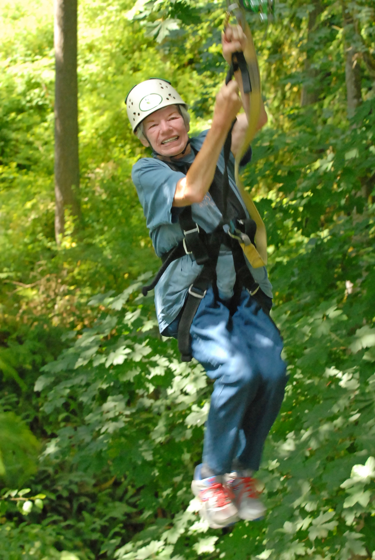
A Thing of Beauty: Chihuly Garden and Glass

Chihuli Glass!One of Seattle’s finest destinations, Chihuly Glass and Gardens, is located at the base of the Space Needle at the Seattle Center. This magnificent exhibit includes three primary components: the Garden, the Glasshouse, and the Interior Exhibits.

A northwest native, Dale Chihuly has led the avant-garde in the development of glass blowing as a fine art. Chihuly was introduced to glass while enrolled at the University of Washington. Upon graduation, he enrolled in the first glass program in the country, at the University of Wisconsin. He continued his studies at Rhode Island School of Design where he later established the glass program and taught for more than a decade. In 1968 he worked in Venice where he observed and later adopted the team approach to glass blowing.

In 1971 Chihuly co-founded Pilchuck Glass School, an international glass art school near Stanwood, WA. He has received wide acclaim, both nationally and internationally, for his innovative and ambitious exhibitions.

At Seattle’s Chihuly Garden and Glass, we walked first into the exhibition entrance, then wandered from room to room, each featuring its own impressive theme: Glass Forest, Northwest Room, Sealife Room, Persian Ceiling, Mille Fiori, Ikebana, and Float Boat, Chandeliers and Macchia Forest. Each room bears a theme in spectacular color and texture that flows on floors, ceilings and walls. The walkway leading to the garden is resplendent with chandeliers.

The magic continues in the Garden with dramatic glass artfully interspersed with live plants, flowers and trees. The Glass House, a 40-foot tall structure inspired by Chihuly’s appreciation for conservatories, includes a 100-foot long suspended sculpture.

The Bookstore features books and materials relating to Dale Chihuly’s artworks. The gift shop has partnered with Northwest companies and many talented artisans to reflect the creative spirit of the region.

The Collections Café features many of Chihuly’s private artwork and projects. The menu shows a selection of fresh local food, and serves lunch, dinner, and a weekend brunch. Admission to the exhibition is not required for dining at Collections Café.

A quote from Dale Chihuly: “I want people to be overwhelmed with light and color in a way they have never experienced.” At Chihuly Garden and Glass, he meets that challenge. From one breathtaking display to another, we were pleasantly overwhelmed with light and color, and gained a deep appreciation for Dale Chihuly and his great contribution to Seattle culture.

For hours, admission fees and driving directions, visit chihulygardenandglass.com
or call 206-905-2180.

High Desert Museum: An Extraordinary Museum

Indian Head Dresses Photo by Roni McFadden

Indian Head Dresses
Photo by Roni McFadden

While attending the Women Writing the West Conference this past October, I had the great pleasure of visiting the High Desert Museum in Bend, Oregon, an excellent all-encompassing museum with many outstanding exhibits.

A temporary exhibit while we were there was “Tough by Nature: Portraits of Cowgirls and Ranch Women of the American West” which showcased Artist Lynda Lanker. Lanker’s heart-felt exhibit features charcoal and graphite drawings as well as stone and plate lithographs, acrylics, oil pastels, and egg tempera. These pictures honor the spirit and stories of ranch women and cowgirls who earn their sustenance and livelihood from the land.

Another temporary exhibit features the work of Edward S. Curtis who spent 30 years beginning in the late 1800s creating a photo-ethnographic study of the North American Indian. Curtis’ collection is widely considered the finest limited edition books ever made in the U.S. The High Desert Museum holds the complete set of the 20 bound volumes of The North American Indian.

The museum has several permanent exhibits. “Spirit of the West” is ever popular and starts with a stroll past a Northern Paiute shelter and a French trapper’s camp. The details depicted are in incredible detail with the sights and sounds of an Indian camp, a settler’s cabin, a hard rock mine, and into Idaho’s old Silver City.

“By Hand Through Memory,” another permanent exhibit, takes visitors through the Plateau Indian Nations’ journey as they traveled from reservation confinement to the 21st Century. Their struggle to retain cultural identity is both poignant and moving.

The High Desert Museum gives visitors a chance to see close-up in both indoor and outdoor displays of live owls, hawks, eagles, falcons, a Canadian lynx and bobcat. None of the animals cared for at the Museum can be released to the wild, either because of injuries or because, separated from their mothers, they never learned to hunt or avoid predators.

Another enlightening permanent exhibit is the Miller Family Ranch where visitors can meet the characters and watch as they do chores (be careful, or you’ll get roped into lending a hand).

As visitors walk around inside the different sections of the building, the outside is brought in by spacious windows looking out on meandering streams in woodsy settings.

The famous Henry James Monk stagecoach, a sawmill, ranger station, a nature walk–it’s all there. If you’re in the Bend, Oregon area, don’t miss this very special museum.

To learn more about the high Desert Museum and read about current and future exhibits, visit http://www.highdesertmuseum.org/

The Layered Look: The Painted Hills of Oregon

Painted Hills 750

You have to keep reminding yourself that what you are seeing is real. The rolling, rounded hills striped with colors of rich rust, deep green, and yellow appear surreal, like an artist’s conception of outer space. You want to capture them on camera quickly before the illusion disappears, just to prove to the folks at home this marvelous pallet of pastels really exists.

Believe it. The Painted Hills in north central Oregon are authentic, and very old. About 30 million years ago, volcanoes from the Cascade Mountains 100 miles to the west deposited layer upon layer of cooled ash over the region. In time, plants and animals churned the surface, water flowed, eroding and redistributing the minerals, and air oxidized the ash. Many different minerals combine to produce the colorful display we see today: aluminum, silicon, iron, magnesium, manganese, sodium, and many more.

Very few plants are able to grow on the Painted Hills. The soils bind water so intensely plants are unable to draw nourishment. So, except in crevasses and gullies where some plants survive, the hills are bare.

From a distance the striped hill surfaces look hard as though they are painted on canvas, but close-up, you can see they have a popcorn appearance and, particularly after a rain, they are soft and spongy. For this reason, visitors are asked to keep on trails and to avoid walking on the hills. Noticeable trails, however, are created by deer and antelope.

Several good walking trails traverse Painted Hills with excellent interpretive signs and brochures. The moderately strenuous, 1.5-mile Carroll Rim Trail rewards the hiker with an outstanding view of the Painted Hills and Sutton Mountain. For a close-up view of a crimson hill and to see the claystone popcorn structure, take the short Painted Cove Trail which winds around the hill on a wooden walkway.

Another interesting hike is the quarter-mile Leaf Hill Trail that takes walkers past the area where large quantities of plant fossils have been removed for study. Except for this trail, fossils are rarely found in the Painted Hills.

The Painted Hills, located 10 miles west of Mitchell, off U.S. 26, is one of three units of the John Day Fossil Beds National Monument. In 1975 Congress established the monument which is composed of 14,000 acres and contains rocks preserving millions of years of plant and animal life. The other two units are the Sheep Rock Unit, near the town of Dayville, Oregon, and the Clarno Unit, 18 miles west of Fossil, Oregon. The Sheep Rock Unit, located at the intersection of State Route 19 and U.S. 26, has several trails and overlooks.

The Clarno Unit, 18 miles west of Fossil, OR, known for its Clarno Nut Beds, is one of the world’s finest fossil plant sources where more than 300 plant species have been found. Several trails allow visitors to see the actual fossils embedded in rock.

Be sure to visit the Thomas Condon Palenotology Center, a National Park Service research facility dedicated to the John Day Fossil Beds. It also serves as the park visitor center and fossil museum. We were fascinated as we watched through a picture window a scientist at work in a laboratory and collections room which contains more than 45,000 specimens.

Another interesting side visit is the James Cant Ranch, located on both sides of the John Day River in the John Day Fossil Beds National Monument. The Cant Ranch complex is preserved as an interpretive site showing visitors an early 20th-century livestock ranch. The James Cant Ranch is listed on the National Register of Historic Places. In addition, there are several short trails with exhibits showing a ranch of yesteryear with original wagons and farming equipment.

There are several camping facilities near Prineville, a small town (population 5,000) about 50 miles southwest of the Painted Hills. Prineville Reservoir State Park, located 17 miles south of Prineville, is a large 70-site facility. In addition, several U.S. Forest Service campgrounds are in the area.

Take your time at the John Day Fossil Beds National Monument. The area, particularly the Painted Hills, is a unique, fascinating place to visit and a photographer’s delight.