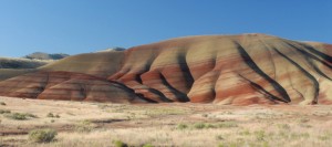
You have to keep reminding yourself that what you are seeing is real. The rolling, rounded hills striped with colors of rich rust, deep green, and yellow appear surreal, like an artist’s conception of outer space. You want to capture them on camera quickly before the illusion disappears, just to prove to the folks at home this marvelous pallet of pastels really exists.
Believe it. The Painted Hills in north central Oregon are authentic, and very old. About 30 million years ago, volcanoes from the Cascade Mountains 100 miles to the west deposited layer upon layer of cooled ash over the region. In time, plants and animals churned the surface, water flowed, eroding and redistributing the minerals, and air oxidized the ash. Many different minerals combine to produce the colorful display we see today: aluminum, silicon, iron, magnesium, manganese, sodium, and many more.
Very few plants are able to grow on the Painted Hills. The soils bind water so intensely plants are unable to draw nourishment. So, except in crevasses and gullies where some plants survive, the hills are bare.
From a distance the striped hill surfaces look hard as though they are painted on canvas, but close-up, you can see they have a popcorn appearance and, particularly after a rain, they are soft and spongy. For this reason, visitors are asked to keep on trails and to avoid walking on the hills. Noticeable trails, however, are created by deer and antelope.
Several good walking trails traverse Painted Hills with excellent interpretive signs and brochures. The moderately strenuous, 1.5-mile Carroll Rim Trail rewards the hiker with an outstanding view of the Painted Hills and Sutton Mountain. For a close-up view of a crimson hill and to see the claystone popcorn structure, take the short Painted Cove Trail which winds around the hill on a wooden walkway.
Another interesting hike is the quarter-mile Leaf Hill Trail that takes walkers past the area where large quantities of plant fossils have been removed for study. Except for this trail, fossils are rarely found in the Painted Hills.
The Painted Hills, located 10 miles west of Mitchell, off U.S. 26, is one of three units of the John Day Fossil Beds National Monument. In 1975 Congress established the monument which is composed of 14,000 acres and contains rocks preserving millions of years of plant and animal life. The other two units are the Sheep Rock Unit, near the town of Dayville, Oregon, and the Clarno Unit, 18 miles west of Fossil, Oregon. The Sheep Rock Unit, located at the intersection of State Route 19 and U.S. 26, has several trails and overlooks.
The Clarno Unit, 18 miles west of Fossil, OR, known for its Clarno Nut Beds, is one of the world’s finest fossil plant sources where more than 300 plant species have been found. Several trails allow visitors to see the actual fossils embedded in rock.
Be sure to visit the Thomas Condon Palenotology Center, a National Park Service research facility dedicated to the John Day Fossil Beds. It also serves as the park visitor center and fossil museum. We were fascinated as we watched through a picture window a scientist at work in a laboratory and collections room which contains more than 45,000 specimens.
Another interesting side visit is the James Cant Ranch, located on both sides of the John Day River in the John Day Fossil Beds National Monument. The Cant Ranch complex is preserved as an interpretive site showing visitors an early 20th-century livestock ranch. The James Cant Ranch is listed on the National Register of Historic Places. In addition, there are several short trails with exhibits showing a ranch of yesteryear with original wagons and farming equipment.
There are several camping facilities near Prineville, a small town (population 5,000) about 50 miles southwest of the Painted Hills. Prineville Reservoir State Park, located 17 miles south of Prineville, is a large 70-site facility. In addition, several U.S. Forest Service campgrounds are in the area.
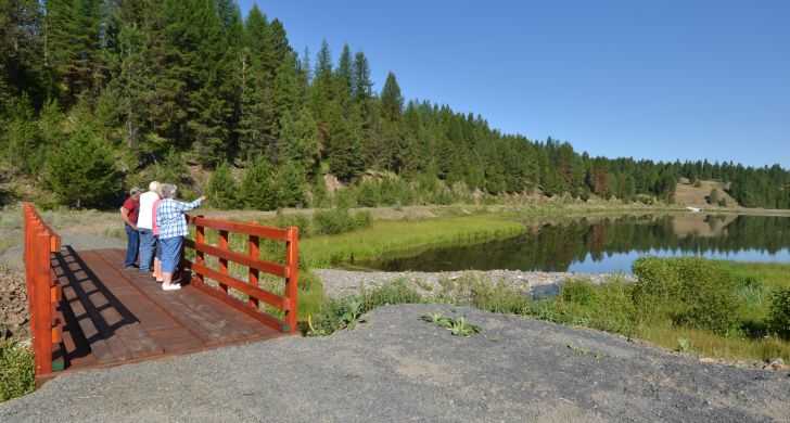
Take your time at the John Day Fossil Beds National Monument. The area, particularly the Painted Hills, is a unique, fascinating place to visit and a photographer’s delight.

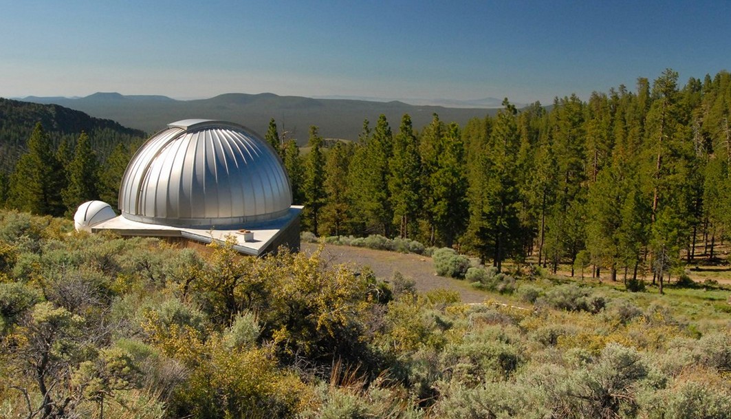 You don’t have to be a hard-core stargazer to enjoy Pine Mountain Observatory, but if you are an astronomer, this is the place for you. The observatory, located 34 miles southeast of Bend, Oregon, is operated by the University of Oregon Department of Physics under a special use permit from the Deschutes National Forest.