Book Review: A Place for Mei Lin

Harlan Hague has written an intriguing historical fiction, A Place for Mei Lin, set in America’s Northwest in the early 20th century.

At one time Caleb Willis was blissfully happy with his wife and two children, but when his family all tragically died, he was without purpose, not caring what happened to him. He drifts from Virginia and settles in Idaho’s Sawtooth Mountains area and sets up a gold dredging operation near Stanley. On a trip to town, he encounters a young Chinese woman, Mei Lin, who had been sold and pressed into service in a brothel. He witnesses abuse to the woman and comes to her rescue.

Not knowing what else to do, he takes her to his cabin. Their relationship grows, but all the while Caleb, still mourning his family, resists acknowledging his feelings toward his young house guest. Mei Lin, on the other hand, feels a gratitude that turns into love toward Caleb. She’s a strong, capable woman who strives to prove her worth.

A Place for Mei Lin is an interesting book on many levels. I have spent quite a bit of time in the Stanley, Idaho area and have seen the old gold-mining dredges and technology described in the book. The author vividly describes the rugged Sawtooth area, giving the novel a strong sense of place. The tragic plight of Chinese during this time is a reminder of our country’s bigotry toward a race of people once their services are no longer needed. And lastly, the novel is a tender love story that at first is one-sided, but soon develops, only to be threatened by forces beyond their control.

This is a novel worth your time, written by a skilled story-teller. A Place for Mei Lin is available in print, ebook and audio formats. To learn more about Harlan Hague, visit http://harlanhague.us/

Idaho’s Bruneau Dunes State Park

Bruneau Obs Dune

On a typical two-week vacation, we stay at a difference place practically every night. Traveling with a truck and camper, this is how we like to spend our vacations. The exception is the weekend between the two weeks. Then we usually try to spend Friday and Saturday nights in the same place, since a campsite can be harder to find on a weekend.

This year, it was our good fortune that we stopped at Bruneau Dunes State Park in southwest Idaho’s high desert. With so much to do and see, it was a perfect place to spend two nights. The 4,800-acre park is the site of North America’s highest single-structured sand dune, which is approximately 470 feet high. (North America’s highest multi-structured dune is at Great Sand Dune National Park in Colorado and is approximately 660 feet higher than its immediate base.)

The dunes at Bruneau are unique in North America. While other dunes in the Americas form at the edge of a natural basin, the Bruneau Dunes form near its center. The dunes are ancient, probably forming with sands from the Bonneville Flood about 15,000 years ago. These dunes are fairly stable with winds blowing from the southeast and from the northwest. Unlike most dunes, these do not drift far.

No vehicles are allowed on the dunes, but visitors may climb and even zoom down on sand boards, similar to snow boards. Seven- and nine-mile horseback riding trails wind around the dunes. An equestrian overnight facility, with corrals, is also available.

We found the campsites spacious with grassy lawns and shade from willow and cottonwood trees. Eighty-two sites have water and electricity, plus there are 31 standard campsites. Two cabins are available for rent.

The park contains several habitats: desert, dunes, prairie, lake and marsh. Wild predators, which are protected within park boundaries, maintain a natural balance of animal population. Fishing for bass and bluegil is popular. It’s a peaceful lake with only non-motorized boats, canoes, rafts and float tubes allowed.

A big attraction at this park is the Steele-Reese Education Center, which includes an observatory. At dusk each Friday and Saturday from April through mid-October local astronomers present a multimedia introduction to the night sky in the comfort of an indoor auditorium. Once the stars begin to twinkle, visitors can observe through the rotating observatory planets, galaxies and nebulae, which I learned is a cloud of gas and dust in outer space. Visitors can observe the night sky through a collection of other equipment, including refractor and catadioptric telescopes.

Bruneau Dunes State Park is just south of Mountain Home, the county seat of Elmore County, and the home to Mountain Home Air Force Base. Mountain Home is a good place to provision and it also has one of the largest laundry facilities I’ve ever seen.

If you’re in southwest Idaho, plan to stop by Bruneau Dunes State Park. It’s a special place.

Book Review: Moonshadows

Moonshadows


Settle in for an engaging period mystery with Moonshadows by Julie Weston.

Nellie Burns steps into a man’s world of photography in the small mining town of Ketchum, Idaho in the early 1920s. In Chicago she’d worked in a photography studio, but only with portraits. Now she plans to follow her heart’s desire with nature photography.

Nellie hires crusty retired miner Rosy Kipling to take her out to capture a winter night scene where “the moon will shine full on and create shadows on snow.” Although he’s never far from his bottle of whiskey, he and Nellie form a sort of bond.

While on her cold night-time trek, she makes a startling discovery at a nearby cabin. She discovers a hideous crime, then another. Nellie uses her talents as a photographer to capture on film what she discovers, but then finds herself embroiled in the mystery. Nellie’s fierce desire to be independent may cause her to be a victim as well. As the story spins into a tight mystery, Nellie emerges as a reluctant heroine, sometimes doubtful of her course, but determined that right will prevail.

The reader sees, through Nellie’s observant eyes, the flavor of Idaho’s rugged landscape in the early 20th Century. Moonshadows is packed with Idaho history, rich characters and information about the early days of photography and its cumbersome equipment. Weston does a worthy job of capturing the spirit of small town living and the attitudes of the day.

Moonshadows is the first of the series, ”A Nellie Burns and Moonshine Mystery.” For more information about the author, visit julieweston.com

Sagebrush: More Than a Weed

Sagebrush 1

At one time I considered sagebrush a sort of useless weed, a wasteland by-product, but since have become fascinated by this important and productive plant and its useful place in a healthy ecosystem.

On a recent trip to central Idaho, we drove for miles on roads winding through sagebrush meadows, a terrain often called prairie or steppe. An attractive roadside sign titled “Wildlife in the Sagebrush Meadow” piqued my interest and when we returned home I delved deeper into the marvels of sagebrush.

Sagebrush comes in a variety of sizes and is a coarse, many-branched, silvery-grey shrub with yellow flowers and silvery-grey foliage. Sagebrush thrives because a long taproot draws water from deep underground. In the meantime, its shallow roots collect scarce rainwater near the surface. Rub a silver-green leaf between your fingers to smell the sagebrush’s distinctive pungent odor, similar to terpentine. Once sagebrush has passed the seedling stage, it can reach ages of more than 100 years. It can grow 2 to 12 feet tall.

Although often too dry to support trees, sagebrush prairies support nest sites and provide cover from wind and predators, harbor food for insect-eating wildlife and provide the main winter food for sage grouse and pronghorn antelope.

Many species of animals call sagebrush “home,” including hundreds of birds, 70 mammals, 23 reptiles and amphibians, 72 spiders and more than 100 insects. Interestingly, pronghorn antelope are the only large herbivores who browse on sagebrush extensively. Some birds, such as sage grouse live nowhere else. These many species are important to the sagebrush ecosystem itself, providing crucial services such as dispersing seeds and preying on insects and rodents. Idaho grows ten different kinds of sagebrush and all provide unique habitat for wildlife prairie dwellers.

In addition, plants and grasses that grow under the sagebrush provide nesting materials and protein-rich insects for birds. Sage grouse depend on mature shrubs for shelter in winter and camouflage nesting sites under the protective canopy of leaves in spring.

Sagebrush habitats across the West have been greatly altered by a century of settlement, livestock grazing, agriculture and weed invasion. With care, these valuable sagebrush prairies can be managed and rejuvenated to enrich habitat for the myriad of wildlife that depend on it.

Here are a few steps that can be taken to preserve sagebrush:

– Eliminate invasive plants, such as cheatgrass that chokes out native sagebrush. Other invasive plants include Russian knapweed, jointed goatgrass, and musk thistle.

– Off-road vehicles, primarily all-terrain vehicles (ATVs) can damage biological soil structure. Their wheels can carry and transport seeds of invasive plants. Regulated areas should be off-limits to such vehicles. In addition ATVs create noise and disturbance to the animals that the sagebrush prairie supports.

– Limit the conversion of sagebrush land to cropland or pasture. Reduce the number of stock allowed to graze the small plants and grasses in sagebrush prairies, and also eliminate grazing May through mid-July to avoid trampling of ground nests and nestlings.

Sagebrush is a rugged plant, but is suffering from human interference. This essential shrub now needs human intervention to protect its vital existence in a healthy ecosystem.

Note: To leave a comment, click on “Leave a Reply.”


In the Immigrants’ Footsteps

ID Covered Wagon 4


As early immigrants struggled along the Oregon Trail, they had a tough decision to make as they made their way through Idaho. Should they risk the danger of crossing the Snake River or endure the dry, rocky route along the river’s south bank?

The original course of the Oregon Trail was from Independence, Missouri to Oregon City in the Willamette Valley. Although fur trappers and explorers used the travel corridor since 1811, most pioneers traveled the trail by wagon train from 1841 through 1848. By the 1860’s the trail was used very little as an emigration route.

The Oregon Trail entered Idaho in the southeast corner of the state. At Fort Hall, it joined the Snake River, following the south bank until a crossing was reached near what is now known as Glenn’s Ferry. The route left Idaho near Fort Boise after winding through 500 miles of the state.

Crossing the Snake was always dangerous, but when the water was low enough to negotiate, everyone who could took advantage of the more favorable northern route to Fort Boise. Those who crossed the river found more potable water and better feed for their stock. But during high water, most immigrants were forced to travel along the South Alternate route into Oregon, a difficult dusty trail that took its toll on man and beast.

About half of the immigrants chose to attempt the crossing by using the gravel bars that extended across the river. Not all were successful and many casualties were recorded in pioneer diaries. Many diaries also recounted how the Shoshone and Piutte Indians helped the immigrants cross the river, claiming they would have never made it without their help.

The Three Island Ford was used by pioneer travelers until 1869, when Gus Glenn constructed a ferry about two miles upstream.

Three Island Crossing State Park is located on the Snake River, just four miles off I-84, 72 miles east of Boise. As weary travelers, we drove into the park in the late afternoon on a scorching hot day. Although we didn’t have a reservation, we lucked out with a lovely, shaded campsite. We breathed a sigh of relief as we settled into our green oasis. Once rested, we enjoyed hiking the trails throughout the park. One of our hikes took us to the site where Gus Glenn’s ferry entered the water. Cables and equipment are still visible and informative signs helped us to imagine immigrants, covered wagons, stock, and freight crossing the river.

A special attraction here is the Oregon Trail History and Education Center where emphasis is placed on the Euro-Americans and Native Americans working together at the Snake River crossing. Many exhibits demonstrate the hardships of the trail. Of particular interest was a packing list for the Oregon Trail and a life-sized covered wagon. The Center also features Native American life, together with a tipi and native craft work. A small theater shows an orientation film about the Three Island Crossing.

Three Island Crossing State Park was a memorable experience with comfortable surroundings and an opportunity to learn of the area’s place in Oregon Trail history.

A Two-Horse Mining Town

Bayhorse
In 1864, two prospectors met a man with two bay horses, horses with hair coat color characterized by a reddish brown body and black mane and tail. The man told the prospectors of a rich mining ground he’d seen. Eventually the site was found and the name Bayhorse given to the creek, town and mining district.

Bayhorse, now a ghost town in central Idaho’s Custer County, is a fun and informative place to experience a fascinating part of Idaho’s mining heritage. Nestled in a narrow, rocky canyon about three miles from where Bayhorse Creek enters the Salmon River, the old mining town was at one time a rich silver and copper producing ground, but now its richness is in its history.

Early residents must have developed strong climbing muscles. Although the trails are well maintained, it takes a little effort to navigate the steep paths to view the interesting nooks and crannies. Go ahead: Stop to rest while looking at the breath-taking view of lush hills covered with aspen and Ponderosa pine.

Informative signage gives visitors the flavor of those long-ago days when, in the early 1870s, a rich vein of silver was discovered. Soon a smelter, mill and eventually a town of 300 sprang up around the steep rocky slope. Before families came, the area was a tough place with lots of whiskey consumed. With the presence of wives and children, the drinking was cut down considerably and it became a much more peaceful, civilized community.

With the success of the smelter, the town grew and businesses thrived. People flocked to the area, including mining engineers, miners, stone masons, loggers, merchants, mill men, businessmen, doctors, cooks and laundrymen. The town included several saloons, meat markets, general stores and boardinghouses. The majority of the buildings were made of wood with local stone foundations. Some of these old buildings still stand.

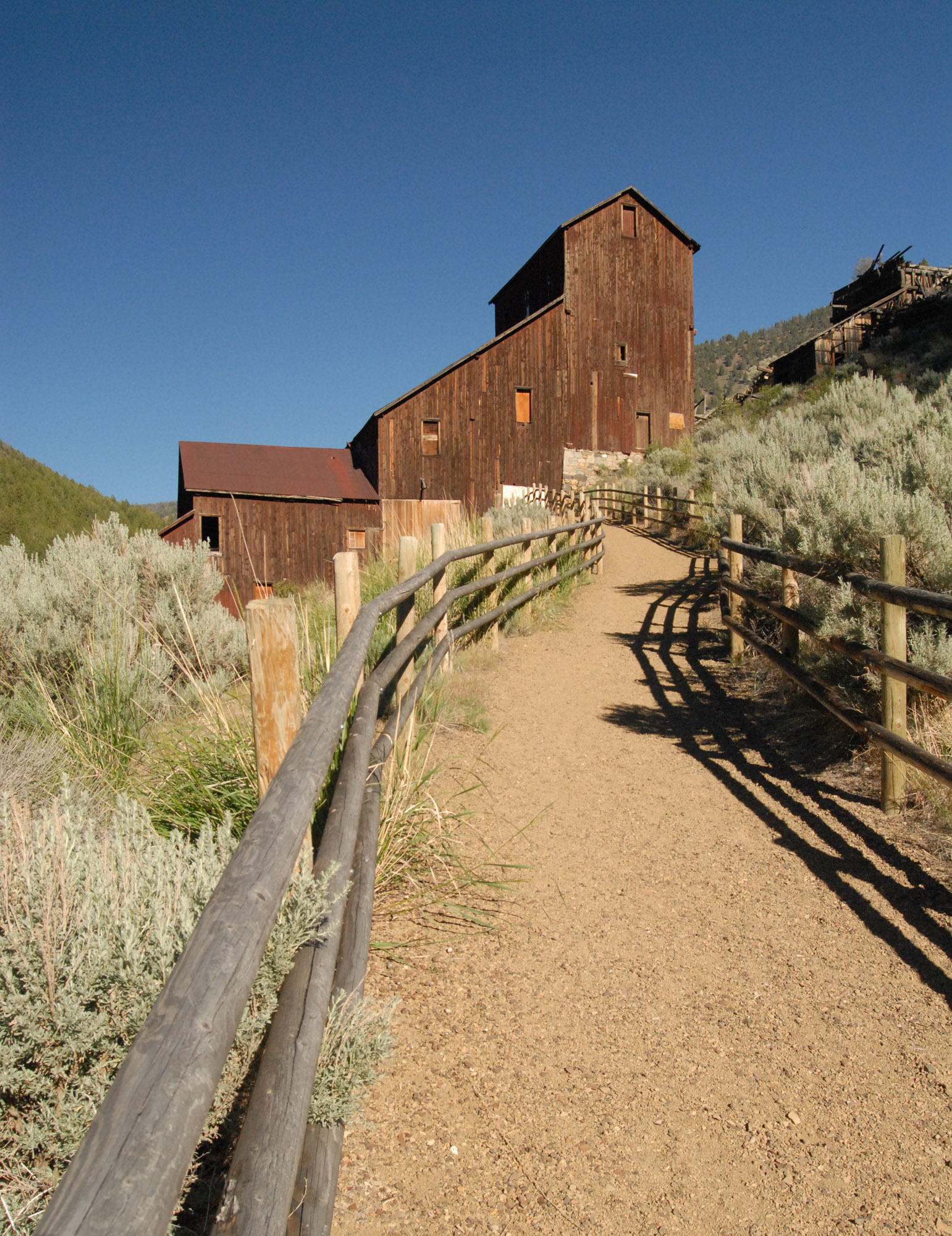
The Bayhorse Mill is the dominant structure of the site. The multi-level mill was built on a hill in descending stair-step levels. It relied on gravity to move the rock through the mill and used water to wash the pulverized rock through the millworks. From there the ore moved across sluice boxes, to settling tanks, and finally to the concentrating tables at the bottom of the mill.

During Bayhorse’s most productive years, 1882 through the 1890s, ten million dollars worth of metals–silver, gold, copper and lead–were extracted from the region. By the turn of the century only a handful of miners remained. In the end, nearly 100,000 tons of ore was pulled from the mountains, leaving more than 25,000 tons of tailings and mine waste. Eventually, devastating fires, dwindling reserves of high grade ore and failing silver prices doomed the town’s existence.

An intriguing stone building, locally called the Wells Fargo Building, is one of the more intact standing buildings. It was possibly named after the design of early Wells Fargo buildings. Although its use is unknown, the sturdy building was possibly used to store bullion before it was transported.

The construction of nine charcoal kilns in 1882 saved transportation costs and created jobs. The conical “beehive” construction needed no bracing and was built of native stone. The kilns were easy and cheap to build and were strong enough to endure the operation’s low heat requirement. More men were required to cut and supply wood for the kilns than to actually operate them. In total, it took 48 men to supply wood and operate the kilns to produce the charcoal to keep the smelter operating. The kilns were abandoned in 1895 and coke was shipped in from Ketchum, ID to operate the smelter.

Transportation was a big problem from the early days around 1870 through the early 1900s. The remoteness and difficulty getting the product out of the area for processing made it almost impossible for the small claim owner to survive. Snow-blocked passes made winter travel impossible. The closest railhead in Blackfoot, Idaho was 375 rough and dangerous miles away. By the time the product was delivered to its destination, the minors often spent more for transportation than they took from the rich earth.

Bayhorse is a part of Idaho’s State Park system and there is a $5 entrance fee. Although there is no overnight camping, the spacious parking lot can easily accommodate RVs. Further up the road, there are a few small campgrounds with no water. We stayed at nearby Bayhorse Campground, managed by the Bureau of Land Management, a nice little place with 14 campsites suitable for RVs, available water and pit toilets. The campground is near the town of Challis, Custer County seat.

To get to Bayhorse mining town: From Idaho Highway 75, between Challis and Stanley, just east of milepost 236, cross a one-lane bridge and you’ll see the signs to Bayhorse.