The Beauty and Power of Mount Rainier

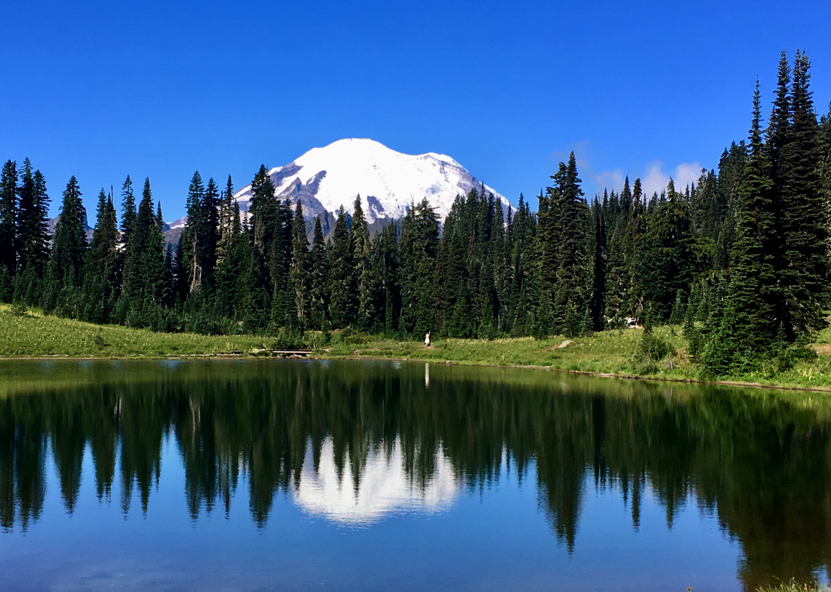
Every few years the urge returns. Mount Rainier, an everyday symbol for north westerners, beckons us with its beauty and power.

Established as the fifth National Park over a hundred years ago, Mount Rainier National Park paved the way in wilderness protection. In 1928, much of the northern and eastern sections of the park were set aside as ”roadless areas” to remain free of roads and commercial development. Today, 97 percent of the park’s 235,625 acres is designated as wilderness.

Times change. In the year 1899, 200 people visited Mount Rainier National Park. Today, nearly 2,000,000 people visit the park each year. Yet we share the same enthusiasm and motivation: to view wildlife and pristine wilderness, to stroll in meadows carpeted with wildflowers, to hike and climb.

From recent geological studies, we know that Mount Rainier is an active volcano and, like Mount St. Helens and other Cascade volcanoes, Mount Rainier will erupt again. Also like Mount St. Helens, volcanologists expect the mountain to give ample warning, but the threat of unexpected mud flows exists throughout the park. Visitors are warned: Be alert in river valleys. If you hear a loud rumbling or notice a rapid rise in water levels, move to higher ground–fast!

Although Mount Rainier, is definitely the star and towers majestically above all other volcanic peaks in the Cascade range, other mountains can be seen from various points: Mounts Hood, Baker and Adams. Emmons Glacier, the largest glacier in the contiguous United States and covering four square miles, can be seen on Mount Rainier’s eastern flank.

Mount Rainier has a long, colorful history of climbers. Although the first attempt in 1857 failed just 400 feet shy of the summit, in 1870 General Hazard Stevens and Philemon Van Trump made the first well-documented ascent. In 1890, Fay Fuller, a school teacher from a small town near Olympia, became the first woman to climb the mountain. Today about 10,000 people attempt to climb the mountain each year and about half of those actually make it to the 14,410-foot summit.

Besides camping, lodging is also available within Mount Rainier National Park. Two rustic lodges offer spectacular views and rooms unencumbered with phones or televisions: The National Park Inn at Longmire, open all year, and Paradise Inn, open during summer months only.

A total of four campgrounds within Mount Rainier National Park offer tent and RV camping: Cougar Rock (SW section of park), Ohanapecosh (SE section), White River (NE section), and Mowich Lake (NW section). No hook-ups are available within the park.

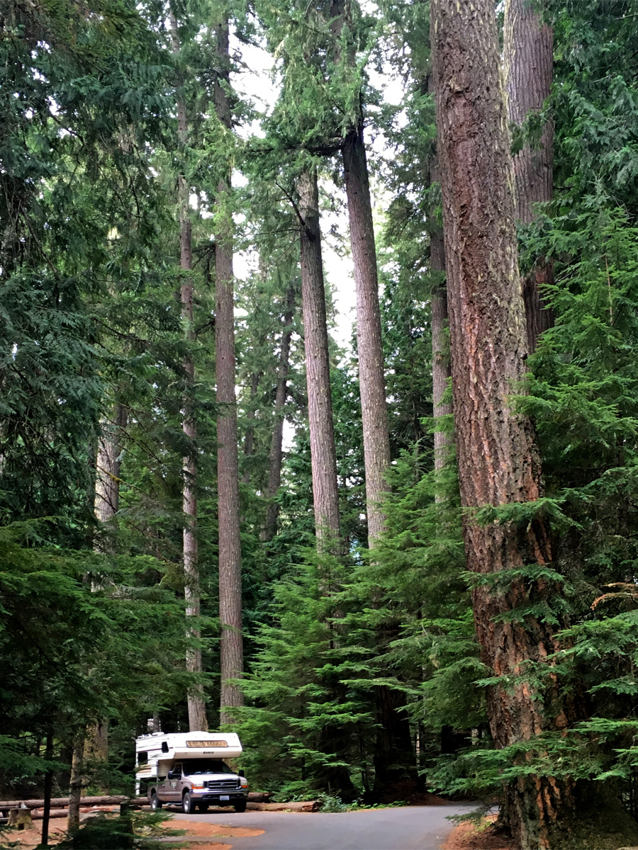
On a recent trip, we camped at Silver Springs Campground, situated on the banks of the scenic White River in Mt. Baker-Snoqualmie National Forest, just outside Mt. Rainier National Park’s North Arch entrance. Silver Springs has stunning scenery and access to a multitude of recreational activities. The 33 standard, non-electrical sites are widely-spaced in a beautiful section of old-growth forest.

Washington’s Mount Rainier is one of our finest destinations. If you’re in the area, don’t pass up a chance to visit Mount Rainier National Park.


A New Discovery: Fort Townsend

On a recent camping trip to the Olympic Peninsula, we found a delightful new park. Well, not really new—Fort Townsend was originally build in 1856—but new to us. The fort operated as a U.S. Army site on and off until 1895. We enjoyed walking the grassy parade ground and reading the interpretive plaques lining the former Officers’ Row.

The park, located just six miles south of Port Townsend along Highway 20, occupies more than a third of the original Fort Townsend built by the U.S. Army for the protection of settlers. Timbers were hewn and laths cut from local forests. After an inspection by an army headquarters commander and deemed unfit, the fort was closed in 1859. Reopened in 1874, the fort thrived until1895 when fire destroyed the barracks. During World War II, the property was used as an enemy-munitions defusing station. Washington State Parks took custody of the premises in 1953.

Several hiking trails meander through thick forests with soaring Douglas-firs, western hemlock, cedar trees and a rich understory of ferns. One of the trails passes an old cemetery site for soldiers who died while in service at the fort. In the late 1890s, the soldiers were reburied at the Presidio in San Francisco, California.

One of the park’s special features is 3,960 feet of saltwater shoreline on Port Townsend Bay.

Compared to many state parks, Fort Townsend is small with only 40 reservable standard campsites and four hiker/biker campsites. Although we didn’t have reservations, we were able to camp in a tranquil, private site.

Another attractive feature of the park, the Friends Barn, a replica of the Fort’s historic stable, is available for rent for weddings, reunions or other group activities. The charming hall has a fireplace and is located between the forest and the beach.

It’s always fun to find new places to camp right here in our own State of Washington, and we found Fort Townsend a lovely new destination.

Olympic National Park’s Wild Coastline

The expansive, diverse 73-mile shoreline of Olympic National Park offers constant delights with crashing waves, tidal cycles and spectacular views. Most of the beaches along this stretch are wide and sandy with superb hiking and beach combing.

Ozette, at the northwest tip of the park, can be reached along a three-mile boardwalk trail to either Sand Point or Cape Alava. A popular day hike is a nine-mile loop, which includes a three-mile beach walk.


One of our favorites, Rialto Beach, a two-mile stretch along Olympic National Park’s wild coast, offers smooth-pebbled black rocks, giant drift logs, pounding waves and magnificent views of offshore islands known as “seastacks.” It is also the start of the shoreline trail that leads to Hole-in-the-Wall, famous for the park’s best locations for tide pools. Rialto also has wide sandy beaches for easy walking.

Three beaches south of Rialto Beach are named First, Second and Third Beaches, and are worthy of exploration.

Kalaloch’s beach, at the south end of the park’s ocean coastline, was named by Seattle Magazine as one of the best ten beaches to winter storm watch. Visitors can spend hours here on wide sandy beaches, exploring tide pools, rocky cliffs and a myriad of driftwood ranging in age from new to ancient.

One of our favorite places to camp just three miles from Rialto Beach is Mora Campground, open year-round. With 94 campsites, we’re almost always assured of finding a site for a night or two. Mora has amenities such as fire rings with grates, accessible restrooms, water and bear-proof food storage. Mora also has a boat ramp and picnic area.

We think of summer as a time to camp, but with the right equipment, camping can be a year-round activity. If you’re not into camping, you’ll find lodging in nearby towns of Forks and Port Angeles. Winter storms along the Pacific Coast offer exciting views. Bundle up and try it.

On any of Olympic National Park’s coastline, you’re guaranteed an exciting outing any time of year.

Malheur National Wildlife Refuge

Over the past many years we have enjoyed visiting Malheur National Wildlife Refuge, located 32 miles south of Burns in the high desert country of southeastern Oregon. A mecca for birdwatchers and wildlife enthusiasts, Malheur is a crown jewel of the National Wildlife Refuge System.

Malheur National Wildlife Refuge was established on August 18, 1908, by President Theodore Roosevelt. The newly established “Lake Malheur Reservation” was the 19th of 51 wildlife refuges created by Roosevelt during his tenure as president. This large refuge now consists of 185,000 acres that include Malheur, Harvey and Mud Lakes, numerous ponds in the Blitzen Valley, alkali flats, towering rimrocks and sagebrush-covered hills.

One of the highlights of the refuge is a museum with nearly 200 mounted bird specimens, giving visitors a rare close-up view of the great diversify the area has to offer.

The 43-mile self-guided auto tour route offers wildlife observations and photography opportunities. It doesn’t take long to immerse yourself in this wilderness atmosphere and to witness a great abundance of life. The sharp call of the killdeer, the gentle quack of a cinnamon teal gathering her fuzzy offspring, and the heron’s motor-like throbbing take-off remind you whose home you’re visiting. The sometimes dank smell of the marsh and even the buzz of mosquitoes demonstrate the importance of an uninterrupted food chain, sometimes uncomfortable for humans but so necessary for wildlife survival.

In January, 2016 Malheur was closed when armed militants seized the headquarters and continued to occupy it until law enforcement made a final arrest in February. The militant organizers were seeking an opportunity to advance their view that the United States Forest Service, Bureau of Land Management (BLM) and other agencies are constitutionally required to turn over most of the federal public land they manage to individual states. Unfortunately, the take-over caused significant damage to tribal artifacts, safes were broken into with money, cameras and computers stolen, a new road was bulldozed, mutilating the surrounding area, and a boat launch was damaged when militants used the area for firearms training. After the occupation, Malheur continued its closure to ensure all explosives and dangerous materials were removed, to clean up the resulting mess, and to restore the grounds. After several months of closure, the refuge is now fully open and operational.

Besides birds and waterfowl, 58 mammal species presently reside within Malheur National Wildlife Refuge.

The Visitor Center is open Monday through Friday from 8:00 am to 4:00 pm and is staffed most weekends by volunteers.

If you’re in southeastern Oregon, be sure to take time to experience this special place.

Oh, Heavens: Pine Mountain Observatory

You don’t have to be a hard-core stargazer to enjoy Pine Mountain Observatory, but if you are an astronomer, this is the place for you. The observatory, located 34 miles southeast of Bend, Oregon, is operated by the University of Oregon Department of Physics under a special use permit from the Deschutes National Forest.

The observatory’s large telescopes allow excellent views of the moon and bright planets. As the sky darkens, tour guides show visitors objects through the various telescopes. A guided binocular tour is also available on some nights. Tour guides point out a variety of celestial objects, including constellations, visible with the naked eye. Questions and comments are welcomed.

Pine Mountain Observatory’s primary function is research and other astronomical observations, including basic and advanced scientific research. However, education at all levels is also an important function and objective of the observatory.

Visitors are welcome on Friday and Saturday evenings, weather permitting, starting Memorial Day through September. “Dark Moon” weekends are best; full moon weekends are least favorable. To see the moon itself, the weekend closest to First Quarter Moon is best.

In the heat of summer, camping here is ideal with 6,300-foot elevation and subsequent cool evenings. The primitive Forest Service Campground, open on a first-come, first-served basis, is located just across the road from the observatory. The camp area consists of four drive-in and ten hike-in sites. There are no camping fees. The camp has one outhouse, but no power hookups, water or trash service. Camping is permitted every day of the week.

Even if your visit doesn’t include observatory viewing, the area offers splendid mountain scenes and hiking.

For more information about Pine Mountain Observatory visit https://pmo.uoregon.edu/visiting/

A Wild Place: Sabino Canyon

Sabino Canyon

While recently attending a Women Writing the West conference at Loews Ventana Canyon Resort near Tucson, AZ, a friend and I took a little side trip to Sabino Canyon for a narrated 3.7-mile tram ride. As we rode in the open-air tram, our driver pointed out the various sites of interest including views of rocky outcroppings, craggy trees, and tough, hardy plants including a variety of cacti: cholla, prickly pear, ocotillo and the great saguaro. We learned that the saguaro can grow to be more than 40 feet tall and that many of the specimens we saw could possibly be 200 years old.

Nine stops along the way allow riders to get out and hike a variety of trails, or have a picnic, then catch a later tram, or riders may stay aboard for the entire trip. We happen to take the last tram of the day, so we stayed aboard for the entire journey. The tram turns around at Stop 9 and heads back down to the Visitors Center.

On our tour, I was surprised to see pools of water as late in the year as October. In spring and summer visitors can even see waterfalls. The Sabino Canyon is a natural desert oasis located in the Coronado National Forest. Sabino Creek gives life to the riparian and desert flora within the canyon. We saw a variety of trees including the Arizona state tree, the palo verde, plus willow, sycamore and ash.

Although I scoured the landscape as we slowly drove by, I didn’t see any wildlife, but the area supports abundant birds, mammals and reptiles. Our driver said that he has seen mountain lion on numerous occasions. Bobcat and coyote have been spotted, along with quails, roadrunners, lizards, and rattlesnakes.

In 1905, the Forest Service began overseeing Sabino Canyon. During the Great Depression, the bridges over Sabino Creek and the Sabino Dam were constructed by the Works Progress Administration (WPA) and Civilian Conservation Corporation (CCC).

The Sabino Canyon Tour was a highlight of my stay in Tucson. Tours are available seven days a week from 8:00 a.m. to 4:30 p.m. For more information call (520) 749-2327, or visit sabinocanyon.org

Saguaro Cactus

Zihuatanejo: A Mexican Delight

View from our condo deck

We recently spent a memorable vacation in Zihuatanejo, Mexico. Zihuatanejo (pronounced see-whah-tah-NEH-ho), the fourth-largest city in the Mexican state of Guerrero, is located on the Pacific Coast, about 150 miles northwest of Acapulco.

Perched on a lush hillside above La Ropa Beach, Ensueño 10, the six-unit condo where we stayed, is beautifully furnished with a great view of the bay. Playa la Ropa (“clothes beach”) was named for a Spanish galleon’s cargo of silks and fabrics brought from the Orient and scattered here from a shipwreck. The condo’s private deck, with an assortment of comfortable outdoor furniture and loungers, served as our headquarters as we planned our activities, read, and ate meals we prepared for ourselves. From our condo we relished in magnificent views of surrounding green hills, and watched the many water sports on the bay: skiing, parachute gliding, boogie boards, and jet skiing. Water taxis sailed between the town pier and idyllic Playa las Gatas.

Although the hills are steep, from our condo we could walk to the beach and stroll along sparkling white sand, passing luxurious hotels, restaurants, and gift shops. Sometimes we choose to hike back up the hill to our condo; sometimes we took a taxi, which proved to be an inexpensive mode of transportation.

On such a vacation, we usually prefer to have some of our meals “in” and we found groceries in Zihautanejo readily available and inexpensive. The kitchen in our condo had all the necessary equipment needed to manage meals with a minimum of hassle.

Fishermen display their day’s catch

Taking a taxi, we rode into town to check out the fishing village. We watched as fishermen brought in and displayed their day’s catch. From there we strolled along a walkway with condos and hotels on one side and the sea on the other. In the sea, a young fisherman, waist-deep in water, threw his circular fishing net. Along the way, we stopped for a delightful lunch at one of the waterfront restaurants.

Another day we strolled among Zihautanejo’s cobblestone streets and visited shops nestled in nooks and crannies. We admired the vibrant colors of Mexican art, and enjoyed observing the culture, listening to conversations in rapid Spanish with traditional Mexican music in the background. Another day we took a water taxi from the town pier and sailed to Playa las Gatas beach. On the small strip of land between the densely forested hill and white-sand beach, restaurants and bars serve meals and drinks; little gift stands feature swimwear and water toys.

Late September and October aren’t usually considered ideal tourist season in this part of Mexico, and we did find it hot and humid, but the upside was that the place wasn’t crowded with tourists and, in fact, we had the condo pool to ourselves. We spent many a happy hour luxuriating in the salt-water infinity pool and reading at the pool-area’s shaded cabana. Although at times it did rain during the night, weather wasn’t a deterrent to our enjoyment.

Enjoying dinner at a beach restaurant

All in all, our time in Zihautanejo was a memorable vacation. We found plenty to do at the pace we wanted to do it. But there’s plenty of other activities, too, whether you have “champagne taste and a beer budget” or seek luxury, glamour and pampering. Your stay can be a tranquil rustic retreat, or more lively with sport activities such as golf, tennis, sport fishing, scuba diving or horseback riding. You’ll find it all in here. Viva Zihautanejo!

Larrabee: Washington’s First State Park

Larrabee State Park has been one of our favorite quick destinations for years. Only an hour’s drive from our home, the park instantly offers a welcomed change of pace and a sense of being far away.

The park is set on the seaward side of Chuckanut Mountain, off the famed Chuckanut Drive, and offers postcard views of Samish Bay and the San Juan Islands. Visitors have their choice of activities from camping, hiking and biking trails, birding and wildlife viewing, salt-water swimming, diving and beach exploration, and shellfish harvesting in season. One of our favorite hikes is to Clayton Beach, which features rare sandstone cliff formations and tide pools teeming with life. In addition to the impressive salt-water beaches, two nearby freshwater lakes, Fragrance and Lost lakes offer bass and trout fishing. A lush growth of Northwest foliage abounds: Douglas fir, western red cedar, alder, hemlock, bigleaf maple, willows, rhododendrons and sword fern.

Larrabee features 85 campsites: 51 standard, 26 full-utility and 8 primitive sites, plus a group camp that can accommodate 40 people. A working train track runs through the park and west of the campground. The park has a boat ramp and a large day-use area with a covered shelter.

Twenty acres of land was originally donated to the State of Washington by the Larrabee family in 1915. The donated land was envisioned as a scenic park/auto campground to complement the Chuckanut Drive section of the nearby completed Pacific Highway. That year, Larrabee officially became the first state park in Washington. Later, the family donated another 1,500 acres. The park now stands at more than 2,600 acres. Many of the park’s original buildings are still in use today, as well as a bandshell built in 1944.

Larrabee State Park is located on Chuckanut Drive, just south of Bellingham, Washington. If you’re in the area, check out this prime park. Maybe we’ll see you there!

Zipline Adventure: Zipping Among Treetops

Recently, our extended family—eleven of us—zipped along the treetops at Canopy Tours Northwest on Camano Island. The unique adventure takes place on the historic 134-acre Kristoferson Farm, which has served the community in various capacities for more than one-hundred years. Today, half of the farm is devoted to growing organic hay and lavender, with the other half devoted to the well-designed zipline tour.

Upon first arriving we were assisted in “suiting” up. The harness has lots of straps and adjustments and our outfits were topped off with a hard hat. Each step of the way we were shown how to work with the equipment, what to expect, and how to land on the various platforms.

The zipline tour consists of six separate lines, each landing on a different platform. Between the zipline sections, our guides led us on lush, green trails. I’ll admit to being a little apprehensive with the first zipline “ride.” Stepping off into a void was a little daunting, even with all the clip-ins and safety gear and in the hands of efficient, certified guides. But I soon relaxed into the adventure as I zipped along old-growth forest, reveling in the rush and the zinging ring of the line, with the assurance that I’d land safely on the platform with a guide’s help.

Once I felt safe, which was actually right away, I found it easy to let go of control and trust the guides and the equipment. We were in good, knowledgeable hands. I simply enjoyed the ride.

Along the way our guides explained some of what we were experiencing such as the various species of trees, the diversity of shrubs and ferns, and what wildlife we might see. The views are fantastic and we enjoyed observing our island from aloft. The zipline tour lasted about two hours.

For a fun adventure, I recommend Canopy Tours Northwest. For more information, visit https://canopytoursnw.com or call 360-387-5807.


Our First Landfall: The Marquesas

Note: The following is taken in part from my memoir, Sailing with Impunity: Adventure in the South Pacific.

We had been at sea for 35 days. Except for the day we left San Diego, we hadn’t seen another boat. It had been just the two of us in a world surrounded by endless water. Like a little kid, I asked Bruce when we would “get there,” reach the Marquesas Islands in French Polynesia.

“Oh, probably early Wednesday morning.”

If that happened, I would be impressed with the exactness of his calculations. Without navigation know-how, you can miss an island by days, going right past it. If an island is more than 10 miles away, a small-craft sailor can’t see it. To cross an ocean with no landmarks, using only the stars and sun for navigation, takes skill.

In any event, I had my sights set on Wednesday. I was ready to get there, to set foot on land, take a long walk, and drink something cold. Strangely, I also felt reluctance to again open our lives to others. We’d been in a world of our own and we were comfortable with that.

On Wednesday, as we approached the Marquesas, from miles away we were aware of the islands’ aroma, a tropical arboretum rich with scents of earth tinted with tropical flowers and fruits. We passed north of Ua Nuka before approaching Nuku Hiva, the largest of the twelve Marquesas Islands.

As we neared land, dolphins greeted us with wild cavorting around Impunity’s bow, slicing the water at extraordinary speeds. Our depth sounder was turned on and the dolphins kept setting off the shallow water alarm. We finally turned off the depth sounder since we had plenty of good light to see any obstacles. I stood in the bow, ready to signal Bruce if I saw any coral heads or changes in water color. I had to laugh at the dolphins’ playful antics as they welcomed us to French Polynesia.

Bruce found a place to anchor among other boats in Taiahoe Bay, yachts from the United States, Sweden, New Zealand, France, Zambia in South Africa, Germany, plus a French Navy ship. The rattling of our ground tackle was a welcome sound as the anchor was lowered 28 feet into the bay.

We made it! We’d traveled 3,200 miles in 34 days. This was the first of many landfalls, but probably the most exciting. We’d proven to ourselves that Impunity was sail-worthy. And so were we.