North Cascades National Park: Wilderness at Its Best

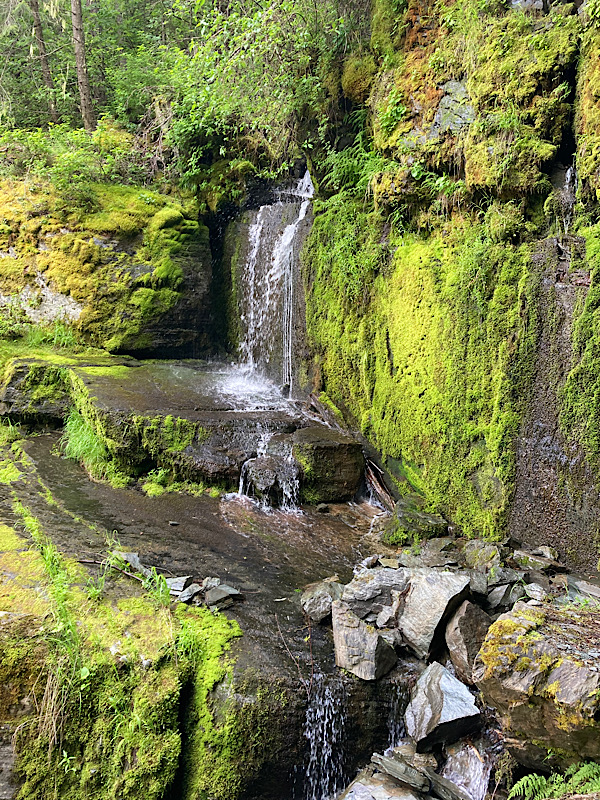
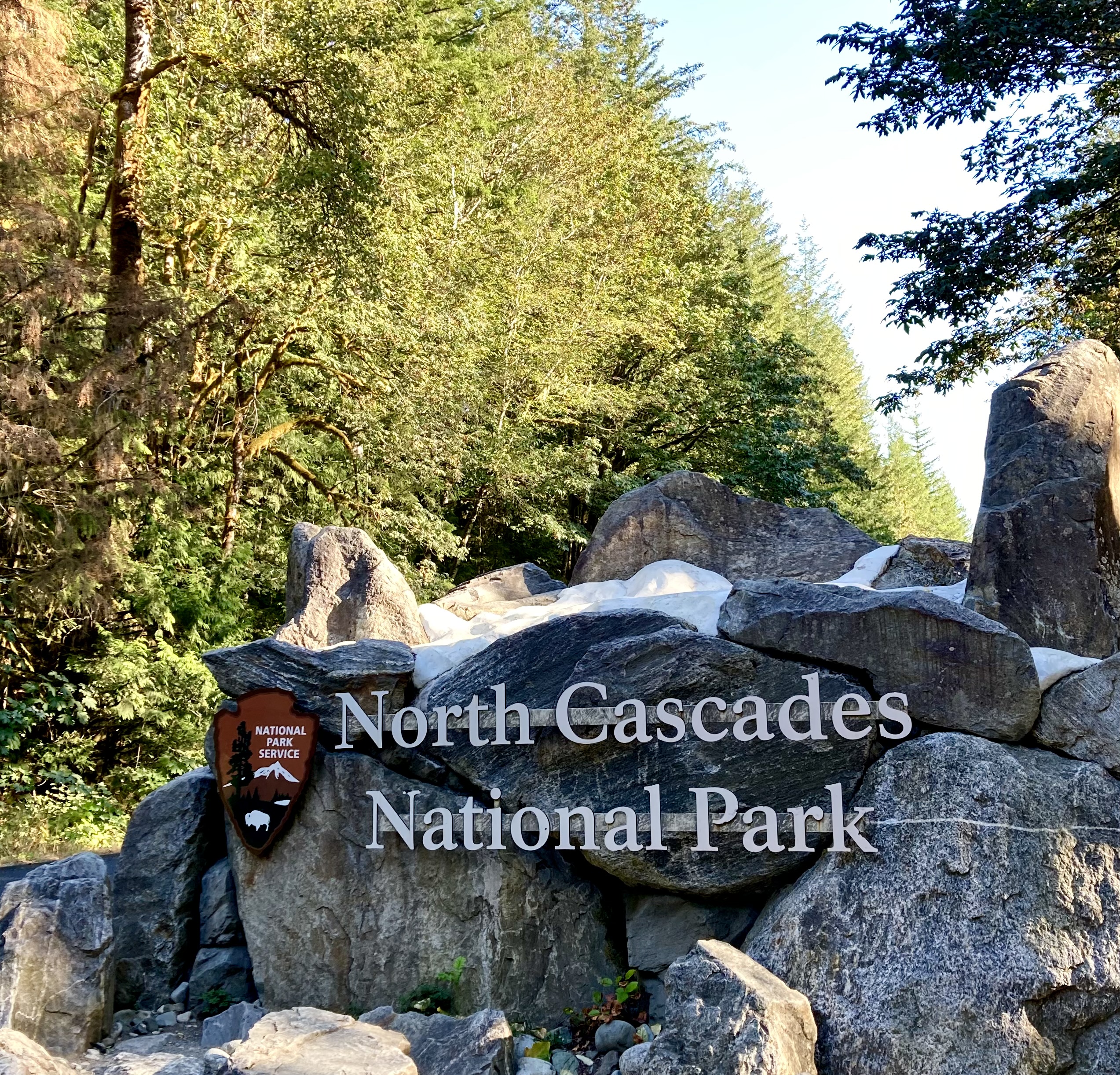
North Cascades National Park in northern Washington State is our kind of place—more than 94 percent of it is protected wilderness. We love to visit and participate in the many aspects of the park including hiking, camping, and water activities. The park shelters grizzly bears and gray wolves, plus more than 200 bird species.

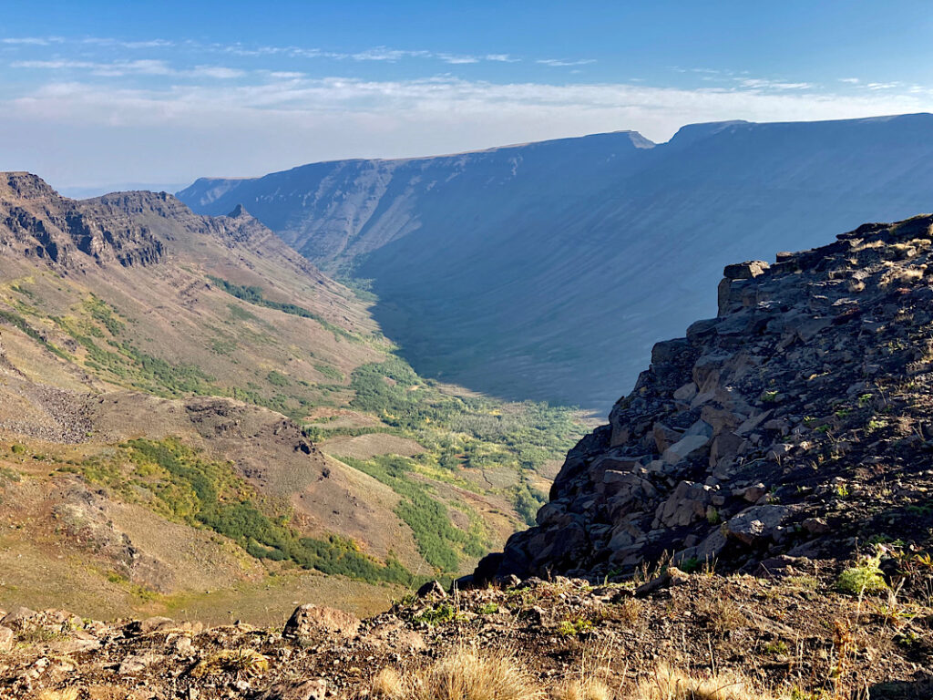
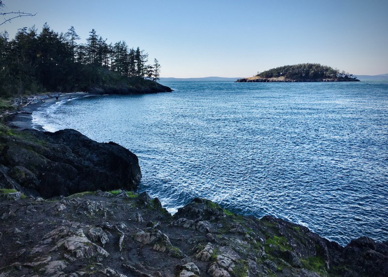
Driving along scenic State Route 20 there’s plenty to see: majestic conifer-clad mountains, glaciers and lakes. Along the way viewpoints lead to hiking trails such as Cascade Pass Trail and the steep Thunder Creek Trail. Crystal clear Diablo Lake, Ross Lake and Lake Chelan offer boating and fishing in season.

Campers have their choice of four campgrounds along State Route 20: Goodell Creek, Newhalem, Colonial Creek and Gorge Lake. We recently camped at Newhalem and found the campsites spacious and with the perfect combination of privacy and convenience. The campground has three loops totaling 107 sites, with each loop containing restrooms and a central water supply. There are also two group camps plus 13 walk-in sites.

Although Newhalem Campground is private and secluded, the town of Newhalem, a visitor center and other amenities are only a short distance away. The Newhalem Visitor Center is one of the finest in the state with exhibits depicting wildlife, complete with sound, a relief map of the park and adjacent forests, a theater featuring video presentations, a sales area with books, maps, videos and other items related to the park, plus several short accessible interpretive trails.

We especially enjoyed three short hikes from the campground. The “Meet a Tree Trail” meanders around the forest with signage identifying various trees found in the area. The “Rock Shelter Trail” took us to a 1,400 year old hunting camp sheltered by a large boulder alongside Newhalem Creek. “Trail of the Cedars” is a self guided nature trail that identifies a wide variety of native plants and animals.

Camping season at North Cascades National Park typically stretches from May to September. State Route 20 is normally closed November through early May depending on snow levels, so plan your visit to North Cascades National Park during late spring through fall.


Before you go, check road conditions online
For more information about North Cascades National Park, visit
https://www.nps.gov/noca/index.htm

THE BLOOMING FIELDS OF SKAGIT VALLEY

It’s like viewing the perfect mural—row upon row of dazzling color—brilliant red, sparkling yellow, vivid pink, rakish purple. Though picture-perfect, they’re real, these delightful tulip fields of the Skagit Valley. Not only tulips, but daffodils and iris grace these lovely fields. Although Mother Nature dictates the bloom dates, daffodils bloom first, followed by tulips and finally, iris.

Now extended to cover the entire month of April, this year’s 40th annual Skagit Valley Tulip Festival also features, in addition to viewing the blooming fields, a packed schedule of events including art shows.

Since the mid-1930s, spring-time visitors to the Skagit Valley have marveled at the striking beauty of tulip, daffodil and iris fields. Northwest Washington, particularly in the Skagit Valley, has become world- famous for its seasonal showcase and for its commercial bulb production. Washington Bulb Company, the nation’s largest tulip, daffodil and iris producer, makes its headquarters in Skagit Valley.

As it happens, the Northwest has perfect bulb-growing climate with cool moist winters, which encourages root growth. Also, relatively cool spring and summer weather helps control diseases common in hotter places. Another factor is well-balanced, level and well-drained soil.

Those who are returning to enjoy the springtime hues will notice that those fields seen last year frequently will not have the same crop this year. That is because flower bulbs, like many other crops, must be rotated to preserve the soil and reduce pest populations. The flowers rotate to their original field about every five years.

Tulip Festival maps are available at many Skagit Valley stores, but it isn’t necessary to have a map to enjoy the blossoms. Signs indicate the “Tulip Route,” or you may simply drive along until you see a field. If there is a pull-off, park and enjoy the view, or even walk along designated paths. Remember, for some traffic on the road, it’s business as usual and drivers aren’t expecting sudden stops. Also, this is a busy time of year for farmers and heavy equipment will be moving about, so please be patient.

The Skagit Valley growers ask for your cooperation in touring the fields. Be aware that only certain fields are open to visitors. Always observe private property; please don’t trespass to get a picture. Enter only those fields with signs posted that visitors are welcome. Never pick a flower—cut flowers are available for sale at various stands.

To get there: The blooming fields are 60 miles north of Seattle, directly off I-5 using exists 221 through 236. All of these exits have tulip brochures at the nearest businesses. The fields are spread out over a 15-mile radius and events are scattered around the entire county. Festival site guide maps are available.

For more information, visit tulipfestival.org or call (360) 428-5959.

Where Eagles Soar: A Northwest Treasure

One of Washington’s most spectacular attractions is the wintering population of Bald Eagles along the Skagit River. Bald Eagles, migrating from British Columbia, Alaska and the interior Northwest, come to the Skagit to feed on spawned chum salmon. Their harsh, creaking cackle splits the air as they go about the business of hunting for their food of prey.

Opportunities abound to view or photograph our majestic national symbol as they congregate along the banks of the Skagit River, typically between December through February. Eastern Skagit County offers one of the largest wintering Bald Eagle populations in the lower 48 states. Peak counts have been estimated at more than 500 birds.

The North American colonists originally gave the Bald Eagle its name when “bald” or “balled” meant white. Bald Eagles feed mostly on fish or seabirds, though they may scavenge larger animals such as deer and even whale carrion.

For its size, the eagle is surprisingly light, yet it is very strong, strong enough to swoop down on prey with incredible speed and carry it away. Eagles’ powerful wings allow them to carry prey that weighs more than they do.

Bald Eagle nests, which can weigh hundreds of pounds, are typically six feet wide and two to four feet tall. Nests are often located very high in a tall tree with a broken or deformed top, within view of the water.

The nesting period in Washington begins around the last week of March to the first or second week of April. Although some eagles stay in the Upper Skagit River area, most find nesting sites around the shores of Puget Sound, San Juan Islands or other coastal areas in Canada or Alaska.

The average adult Bald Eagle weighs nine pounds, with a height of three feet and a wing span of five-and-a-half to seven-and-a-half feet. It is presumed that eagles mate for life. They are generally ready to mate at the age of five. Females lay two to four eggs and the 35-day incubation duties are shared by both female and male.

Eaglets are fed by their parents for the first six to seven weeks and then sporadically while they learn to feed themselves. By the time young eagles emerge from the nest they are almost as large as their parents. The familiar coloring of white head and tail, however, does not occur until the birds are four or five years of age. Juvenile birds are mostly brown and gray with mottling on the underside of their wings and a black tail with some gray.

The average life span of an eagle is up to 20 years in the wild and 40 years in captivity. The Bald Eagle was almost driven to extinction as the result of eggshell thinning caused by the pesticide DDT. DDT was banned in the 1970s and the eagles, as well as other birds of prey, have made an amazing comeback.

Someone who can see great distances is said to have “eagle eyes.” Few animals can match the eagles’ ability to see distant objects; in fact, the eagle can see tiny detail three to four times farther than humans.

Eagles can normally be observed feeding on the gravel bars of the Skagit River during the morning hours between 7 and 11 a.m. Or, later in the afternoon, you can watch the birds catch updrafts and soar overhead. At other times the birds are seen sitting on mossy tree branches along the river. This “quiet time” is an important period when the birds conserve energy. Our favorite viewing site is on State Route 20, which runs along the Skagit River, near Rockport.

The American Bald Eagle is protected by Federal law. Follow these tips for your eagle viewing pleasure and for the protection of these magnificent birds.

  • Maintain a 1,000 foot distance from eagles
  • Your car makes a great viewing blind
  • Keep pets in your vehicle
  • Move slowly, talk softly
  • Never throw objects to make the eagles fly
  • Use telescope, spotting scope, binoculars or a telephoto lens to see eagles “up close.”

Bridgeport State Park: A Desert Oasis

It was a blistering hot day in central Washington. We’d been on the road for hours and were ready for some creature comfort. We found it at Bridgeport State Park on the north shore of Rufus Woods Lake.

The bountiful shade trees and lush grass at the park were a welcomed treat. The 622-acre park, located in the midst of North Central Washington’s desert, is situated directly behind Chief Joseph Dam.

Rufus Woods Lake, a reservoir of the mighty Columbia River, is abundant in rainbow trout, silvers and walleye. The lake is also popular for boating, swimming, waterskiing and sailboarding. The park has two watercraft launches and a 240-foot dock.

Besides water activity, the park offers four miles of ADA-compliant hiking trails.

On the north side of the park, “haystack” volcanic formations are a reminder of the area’s turbulent geology. The rock formations were formed by lava flows millions of years ago.

The park has both electrical hook-up and standard campsites, each featuring a picnic table and fire ring, and a group camp that accommodates up to 72 guests. The day-use area has two covered picnic gazebos, plus 10 unsheltered picnic tables.

On Saturdays during the summer, interpretive programs are provided by the U.S. Army Corps of Engineers. Subjects include the operation of Chief Joseph Dam and area wildlife.

While in the area, take the time to visit Chief Joseph Dam, the second largest hydropower producing dam in the United States. Built by the US Army Corps of Engineers, the dam produces enough power to supply the whole Seattle metropolitan area.

Bridgeport State Park was a nice change from our usual more rugged style of camping. We found the park a great place to chill out with time in the sun and plenty of shade to cool off afterwards.

From Coastal Defense to Outdoor Fun: Fort Ebey State Park

Fort Ebey on Whidbey Island is one of Washington’s finest state parks. Our recent camping trip reminded me of what a treasure this 651-acre park is with its historical value, camping, and hiking/biking trails. The fort was acquired by Washington State Parks in 1968 and opened to the public in 1981.

Located on the western side of Whidbey Island, Fort Ebey originally was constructed as a coastal defense fort during the Second World War. The fort’s gun battery and underground rooms were built into a hillside and are great fun to explore. From there visitors can walk along the high bluff with magnificent views of Puget Sound’s Admiralty Inlet and Point Wilson Lighthouse across the bay. If you’re in luck, you might catch someone paragliding off the high bluff.

Fort Ebey offers 38 standard and 11 partial hook-up campsites, plus a group camp that accommodates up to 60 people. Picnic tables and fire rings are available at campsites with restrooms close by.

Day-use facilities at the fort offer two reservable log picnic shelters that will accommodate large groups. Several unsheltered picnic tables and BBQ grills are also available in the day-use area on a first-come, first-served basis.

One of the draws of Fort Ebey is its access to Kettles Trails for hiking and biking. Some of the trails are wide and flat, others winding and steep. The area, named for the depressions formed by melting blocks of ice that broke free from an ancient glacier, offers 25 miles of pristine forested trails sprinkled with pink big-leaf rhododendrons in season. Beach walking and surfing are also popular activities at the park.

We love Fort Ebey and over the years have camped there many times. We highly recommend this park for camping, picnicking and as a place to view an historical World War II defense fort.

Among Ancient Forests: Washington’s Rasar State Park

Winter and early spring in the Northwest can be a little bleak, but Rasar State Park (pronounced “Racer”) offers plenty of opportunities for fun during what is normally considered off-season. Rasar is located on Highway 20, six miles west of Concrete, between Hamilton and Concrete. The 168-acre park is open year round.

One of the main focuses of Rasar is its wildlife-friendly atmosphere. Much of the land has been left in its natural state and is lush with ferns, salal and other natural shrubs protected by an umbrella of cedar, hemlock and deciduous trees. We found winter-dormant maple branches thick with bright green moss and studded with growing ferns.

Wildlife who make this area home include elk, cougar, deer, coyote, river otter, beaver, salmon and trout. A large meadow that at one time had been a hayfield, has been left in the park’s design as a reminder of pioneer use of the land, and its open expanse offers an interesting contrast to the surrounding wooded area and also serves as habitat to wildlife.

The Skagit River, third largest on the west coast of the contiguous United States (next to Columbia and Sacramento Rivers) is the largest watershed in the Puget Sound Basin. Standing on its shores, visitors may luck out and spot an eagle sitting on a mossy tree branch. In bygone days, the river offered transportation by boat for indigenous and pioneer residents.

The two-level park is well designed with an attractive office and visitors’ station on the upper level, along with other buildings, roads, picnic area and campsites. Many of the large timbers used in the park buildings came from trees on the property. Stone from the area also was put to use in creating signs, fireplaces and chimneys.

The park has 18 standard sites, 20 partial-hookup with electricity and water (two ADA), eight walk-in sites and three primitive hiker/biker sites, as well as two Adirondack (three-sided) sleeping shelters available to walk-in campers. The sites are roomy and many are drive-through. Restrooms in the camping area have hot showers. Each camp site has a charcoal cook stove and picnic table. Three group camps offer privacy for families, scouting troops and other group gatherings. Three cabins, tucked in cozy forest settings, are also available. Each cabin is 16-by-25-feet and will accommodate up to five guests.

The picnic area has a large kitchen shelter, picnic tables, electrical outlets, and outdoor charcoal grills. Playground equipment is nearby and there are several picnic tables for day visitors. Reservations may be made for the kitchen shelter.

The lower portion of the park has been left largely undisturbed. On a gradual decent, the ADA black-topped trail winds its way to the Skagit River with interpretive stations along the way. Fishing along the river offers opportunities for salmon, steel head and trout. From November through February, the park serves as an excellent base camp to see the annual migration of bald eagles along the upper portions of the Skagit River.

Nearby attractions include Newhalem and the North Cascades National Park Visitor Center and Seattle City Lights Hydroelectric complex. Other activities to enjoy in the area include the Marblemount salmon rearing ponds and hatchery, and Howard Miller Steelhead County Park in Rockport, where the last Skagit River ferry is on display.

When visiting Rasar State Park this time, we took advantage of our Washington State Park Off-Season Pass. Any time of year is a good time to visit Rasar, but this park offers plenty to do in those months when sunshine can be a little scarce.

Website: www.parks.state.wa.us/571/Rasar or call (360) 826-3942

Steens Mountain: Oregon’s Wonderland

Steens Mountain from Kiger Gorge Overlook

The backcountry wilderness that surrounds Steens Mountain in Southeastern Oregon is one of the state’s finest scenic and geologic destinations. Steens Mountain is actually a small 30-mile mountain range rather than a single peak.

We recently spent a few days in the Steens area camping and driving the Steens Mountain Wilderness Loop. Visitors have their choice of four Bureau of Land Management (BLM) campgrounds, three on the North Loop road and South Steens Campground on the South Loop road, where we stayed with our truck and camper. The sites, surrounded by juniper and sage, are spacious and each is equipped with a picnic table and grill with central water available. An equestrian camp site, designed specifically for horse users, is directly adjacent to the family campground.

On a lovely sunny day we drove the 59-mile loop, a fairly well-maintained gravel road, which climbs to nearly 10,000 feet, the highest road in Oregon. This is open range country, so we did stop at times for cattle on the roadway. The views are spectacular with steep craggy hills and glacier-carved valleys rimmed with sagebrush and quaking aspen, sprinkled with a few small lakes. Kiger Gorge, a U-shaped glacial valley, is home to a herd of wild mustangs.

The next day we took an interesting side-trip near the South Steens campground to the Riddle Brothers Ranch, a historic piece of Oregon’s pioneer settlement. Bachelor brothers Walter, Frederick, and Benjamin Riddle obtained water rights, built homes and raised livestock on the ranch in the early 1900s. Some structures still stand with handcrafted furnishings, surrounded by equipment used in that time period. The property is now managed by the BLM for its historic values.

Visitors must be mindful of Steens Mountain’s high elevation and possible rapid temperature changes. The weather can be blustery with strong winds, blistery with 100-degree days, or with blinding snow that can fall year-round. For much of the year, snow prevents passage so planning a visit in the late summer and early fall are the most likely times for travel.

Steens Mountain is a worthwhile destination with a wide variety of scenes and activities. It was a highlight of our late-summer camping trip that we’d looked forward to for a long time.

To check weather and travel conditions before you travel to the Steens Mountain area, call the BLM office in Burns, Oregon: 541-573-4400.

Lemhi Pass: A Doorway Through the Rockies

On a recent camping trip to Idaho and Montana, we drove through Lemhi Pass. Approaching from the Montana side on a hot, clear June day, we wandered around the summit, marveled at the sweeping views, and visited the Sacagawea Memorial. Mid-week, we were the only visitors and could take our time to soak up the history and majesty of our surroundings.

The Shoshone Indians and other tribes commonly crossed what later became known as the Continental Divide. Their footsteps and horse hooves created a clear trail for Lewis and Clark to follow in 1805. The trail through the rugged Bitterroot Range of the Rocky Mountains is a passageway between the Salmon River Valley to the west, and Horse Prairie to the east. Later, mountain men and fur traders called it “North Pass.”

A high mountain pass in the Beaverhead Mountains and part of the Bitterroot Range in the Rocky Mountains, Lemhi Pass is within Salmon-Challis National Forest. The pass lies on the Montana-Idaho border on the continental divide, at an elevation of 7,373 feet above sea level.

The name Lemhi dates back to 1855 when Mormon pioneers built Fort Limhi, named after a king in the Book of Mormon. Later the spelling was changed to Lemhi and the name remained with the land and its people, the Lemhi Shoshone.

Falling rain creates an interesting phenomena in this area. Rain falling east of Lemhi Pass drains to the Missouri and later the Mississippi River, then into the Gulf of Mexico. However, rain falling west of the pass drains into the Salmon, Snake and Columbia Rivers and eventually into the Pacific Ocean.

Lemhi Pass is a spectacular place. If you have an opportunity to visit, don’t pass up this high-level delight.

Climbing High: The St. Joe River Scenic Byway

Photo by Bruce Trimble

One of the highlights of our recent camping trip was journeying along one of Idaho’s finest scenic drives, the 89-mile St. Joe River Scenic Byway. Climbs, dips and sweeping turns produce one amazing view after another. Alternately called Forest Highway 50 and St. Joe River Road, the drive climbs from St. Maries, Idaho to Gold Pass at the Montana border. You see it all on this drive: forested mountains, towering trees, rapids, water falls, pristine streams, wildlife, and, in June wildflowers grace the hillsides.

On a side trip to Moon Pass, above Avery, the road partially follows the old Milwaukee Road rail line and one of the thrills we experienced was driving through seven decommissioned train tunnels. Blasted through solid rock, the tunnels are one lane. In some instances, the tunnels curve and we had the added thrill of hoping no one was coming from the opposite direction.

We stopped at one point to take a picture of a charming waterfall just outside a tunnel. The day was hot and the fine spray from the cascading water was a welcome relief.

Photo by Bruce Trimble

Whether you’re just driving through, hiking, biking, river rafting, kayaking, or staying at one of several peaceful campgrounds, the St. Joe River Scenic Byway is a spectacular destination. The road closes for the winter, so check travel conditions before taking in this drive. We traveled it mid-June, which was perfect.

Washington’s Treasure: Deception Pass State Park

Looking west from Deception Pass State Park

Among the many Washington treasures are its state parks. We recently camped using our truck and camper at Deception Pass State Park. The park spreads over 3,854 acres and includes both saltwater shoreline and three lakes. Located in northwest Washington, the park has three campgrounds: Cranberry Lake and Quarry Pond Campgrounds located on Whidbey Island to the south and Bowman Bay on Fidalgo Island to the north. The two islands are connected by a pair of bridges known collectively as Deception Pass Bridge.

Campsites offer ocean, mountain, forest, or lake views. Visitor facilities include utility sites with water and electricity, and tent sites. All camping spaces are equipped with a picnic table and fire ring.

In addition to superb camping, the park offers services for water activities which include two docks, boat launches and moorage. Boating, kayaking, freshwater and saltwater fishing, crabbing, swimming, and SCUBA diving are among the many water activities enjoyed at the park.

The park offers 38 miles of hiking trails through lush forest lands and along shorelines. In addition, there are 1.2 miles of ADA hiking trails, 3 miles of bike trails, and 6 miles of horse trails.

Besides soaking in nature’s bounty in our spacious site at Cranberry Lake Campground, we enjoyed a morning drive north to Anacortes, known for the Washington State Ferries dock and terminal serving San Juan Islands as well as Victoria, British Columbia. Another day we drove south to Coupeville, the county seat of Island County, and the second oldest community in Washington. Nearby Keystone is also the jumping off point via ferry to the Olympic Peninsula.

From many places in the park, visitors can see work done by the Civilian Conservation Corps (CCC) in the 1930s. At the Bowman Bay campground a CCC building was renovated in 1987 that exhibits the incredible story of the CCC’s work across the State of Washington during the Great Depression.

We recently purchased a Washington State Park off-season senior citizen pass for $75. This pass entitles pass holders to free camping and moorage between October 1 and March 31, as well as Sundays through Thursdays in April. Our three-day camping trip to Deception Pass State Park paid for this pass, so for the rest of the season our camping will be free.

Deception Pass State Park, open all year, is one of Washington’s most popular parks. Reservations are highly recommended (www.parks.state.wa.us or call (888) CAMPOUT to make reservations).